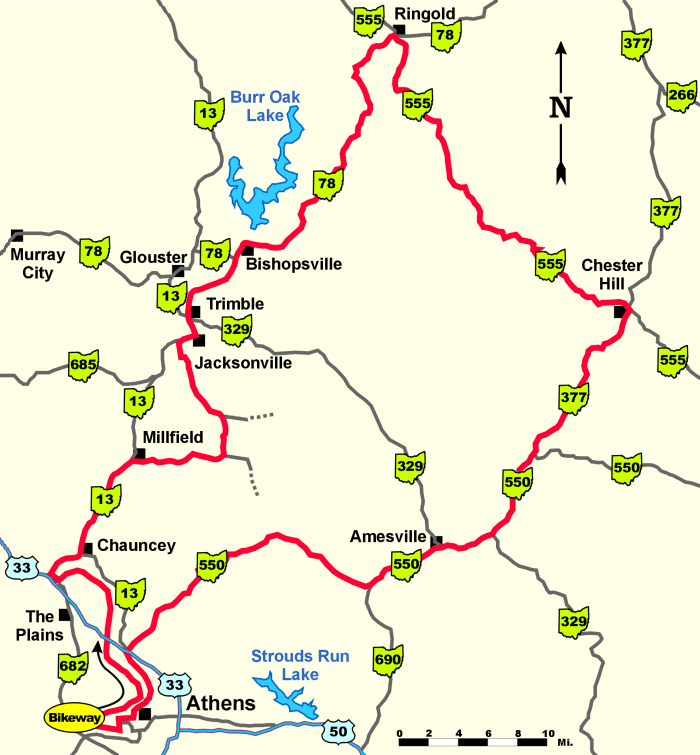
ABOVE: The Profile of the Rim of the World starting and ending at West State Street Ball Fields.
The first hill is just outside of New Marshfield on CR 27. This is a good first test for how your climbing legs are going to feel for the rest of the ride.
The center section of hills is the "Rim" section starting out of Trimble and extending to Chester Hill (a 22.8 mile undulating section). Just after the town of Ringold at the total trip mile 28.7, there are three very closely spaced hills nicknamed "The Three Sisters". Here the grade steepens to a nasty 18% on the first two "Sisters".
The second to last large peak is Dividing Ridge on State Route 550 and the last small climb is going up Columbus Road (SR 550) into Athens. You can add Terrace Lane if you still have any gas in the tank.
RIM of the WORLD Directions and notes
Dist.
Trip
Go
Description
Start at the West State Street Ball Fields and as you face the river bed turn right and head North up the path to Beamont.
(6.2)
R
on to SR 682 - over the Hocking River / Chauncey to Millfield
0.2
(6.4)
BR
on SR 682 away from the highway (US 33)
1.0
(7.4)
L
on to SR 13 into Downtown Chauncey and beyond
2.9
(10.3)
R
on to Main Street in New Marshfield (CR 93)
0.5
(10.8)
R
on to Millfield Rd (Millfield-Jacksonville)
1.2
(12.0)
BR
still on Millfield Rd (CR 27)
0.1
(12.1)
BL
staying on Millfield Rd (CR 27)
1.6
(13.7)
BR
staying on Millfield Rd (CR 27) at the Monserat Rd intersection
0.1
(13.8)
BL
still on Millfield Rd at the Concord Church Rd itersection
2.5
(16.3)
CS
over Sunday Creek on to Sixth St in Jacksonville
0.2
(16.5)
R
on to SR 13 (Main St)
1.0
(17.5)
R
on to SR 329 in Trimble
0.1
(17.6)
L
on to Valley
0.4
(18.0)
BR
over the railroad tracks on to Congress Run Rd (CR 32)
0.3
(18.3)
R
on CR 32 (Congress Run Rd)
0.7
(19.0)
BL
on CR 32 (Congress Run Rd)
0.9
(19.9)
BR
on to SR 78 into Bishopville
8.8
(28.7)
R
in Ringold and on to SR 555
11.6
(40.3)
R
on to SR 377 in Chesterhill
5.0
(45.3)
CS
in Sharpsburg on to SR 550 (past the gas station on your left)
4.0
(49.3)
CS
on SR 550 in Amesville
12.4
(61.7)
R
on to 2nd St Athens (at the stop light at the top of the hill)
0.4
(62.1)
L
at the bottom of the steep down hill on to Central Ave
0.2
(62.3)
R
on to W State St
0.6
(62.9)
Finish at W State St Ball Field parking lots
R = Right Turn L = Left Turn CS = Continue Straight BR = Bear Right BL = Bear Left
.
Ride responsibly
Cycle Path recommends wearing a helmet, obeying all traffic laws, and riding within your limits.